


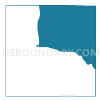
Voting District 0003, Stephens County, Texas
About
Outline

Summary
| Unique Area Identifier | 676827 |
| Name | Voting District 0003 |
| County | Stephens County |
| State | Texas |
| Area (square miles) | 307.99 |
| Land Area (square miles) | 306.53 |
| Water Area (square miles) | 1.46 |
| % of Land Area | 99.52 |
| % of Water Area | 0.48 |
| Latitude of the Internal Point | 32.84137740 |
| Longtitude of the Internal Point | -98.72040170 |
Maps


Graphs
Select a template below for downloading or customizing gragh for Voting District 0003, Stephens County, Texas


Neighbors
Neighoring Voting District (by Name) Neighboring Voting District on the Map
- Voting District 0001, Stephens County, TX
- Voting District 0004, Stephens County, TX
- Voting District 0005, Palo Pinto County, TX
- Voting District 0006, Stephens County, TX
- Voting District 0006, Young County, TX
- Voting District 0009, Palo Pinto County, TX
- Voting District 0020, Palo Pinto County, TX
- Voting District 0022, Young County, TX
Top 10 Neighboring County Subdivision (by Population) Neighboring County Subdivision on the Map
- Graham CCD, Young County, TX (13,070)
- Breckenridge North CCD, Stephens County, TX (8,375)
- Graford CCD, Palo Pinto County, TX (2,599)
- Strawn-Gordon CCD, Palo Pinto County, TX (2,191)
- Breckenridge South CCD, Stephens County, TX (1,255)
Top 10 Neighboring Place (by Population) Neighboring Place on the Map
Top 10 Neighboring Unified School District (by Population) Neighboring Unified School District on the Map
- Graham Independent School District, TX (13,559)
- Breckenridge Independent School District, TX (9,515)
- Graford Independent School District, TX (2,323)
- Palo Pinto Independent School District, TX (1,072)
- Strawn Independent School District, TX (791)
- Woodson Independent School District, TX (508)
Top 10 Neighboring State Legislative District Lower Chamber (by Population) Neighboring State Legislative District Lower Chamber on the Map
Top 10 Neighboring State Legislative District Upper Chamber (by Population) Neighboring State Legislative District Upper Chamber on the Map
Top 10 Neighboring 111th Congressional District (by Population) Neighboring 111th Congressional District on the Map
Top 10 Neighboring Census Tract (by Population) Neighboring Census Tract on the Map
- Census Tract 9504, Young County, TX (5,720)
- Census Tract 9502, Stephens County, TX (4,149)
- Census Tract 9505, Stephens County, TX (3,139)
- Census Tract 1, Palo Pinto County, TX (2,599)
- Census Tract 9503, Stephens County, TX (2,342)
- Census Tract 2, Palo Pinto County, TX (2,191)
Top 10 Neighboring 5-Digit ZIP Code Tabulation Area (by Population) Neighboring 5-Digit ZIP Code Tabulation Area on the Map
- 76450, TX (13,258)
- 76424, TX (8,992)
- 76470, TX (3,238)
- 76475, TX (977)
- 76429, TX (258)
- 76481, TX (208)